The Tour des Glaciers de la Vanoise is one of the most beautiful multi-day treks in the French Alps. Ideal for experienced hikers and nature lovers from around the world, this trail is surely a once-in-a-lifetime expereince.
This article will guide you through the details about the Tour des Glaciers de la Vanoise Trail, find out what gear is essential, and get practical tips for staying safe. This guide will help you start planning your Tour du Glacier de la Vanoise with confidence.
What is the Tour des Glaciers de la Vanoise?
The Tour des Glaciers de la Vanoise, which translates as the Tour of the Vanoise Glaciers, is a 70 km loop trail in the Vanoise National Park. This is France’s first national park, established in 1963 to protect the area’s biodiversity and alpine landscapes. This route circles the impressive glaciers of the Vanoise massif, with panoramic views of snow-capped peaks, passes, and meadows filled with alpine flowers.
The trail is demanding, with around 4,000 meters of elevation gain. It’s especially popular among experienced hikers and trail runners who want a real challenge.
What is the route of the Tour des Glaciers de la Vanoise?
The Tour des Glaciers de la Vanoise Trail traditionally begins and ends in Pralognan‑la‑Vanoise at 1,400 m. This is a charming village in the Tarentaise valley. From here, most hikers typically follow a clockwise loop.
There are four main stages of the loop.
Stage 1: Pralognan → Refuge du Col de la Vanoise
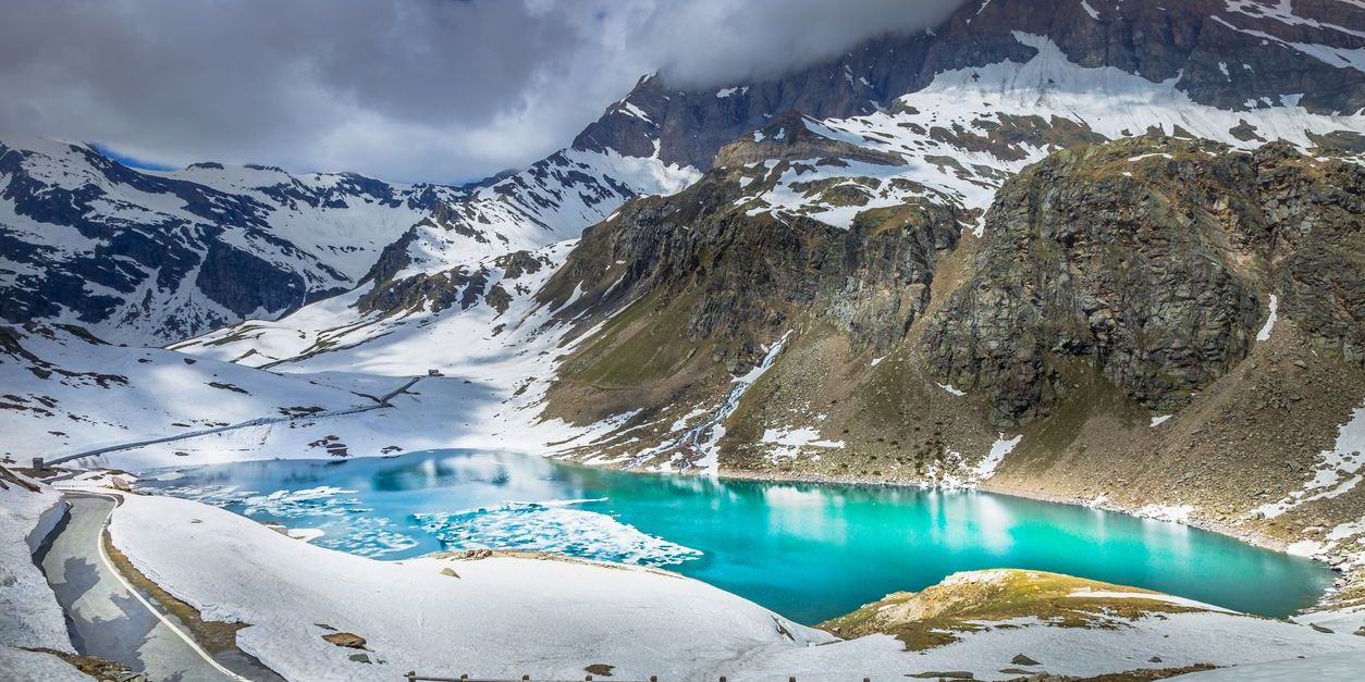
This first stage covers about 7 km with an elevation gain of around 1,100 m. Beginning at GR55, you gradually ascend past the Lac des Vaches before climbing toward the Col de la Vanoise at roughly 2,517 m. Along the way, you will see views of the Grande Casse and the Aiguille de la Vanoise.
Stage 2: Refuge du Col de la Vanoise → Refuge de l’Arpont
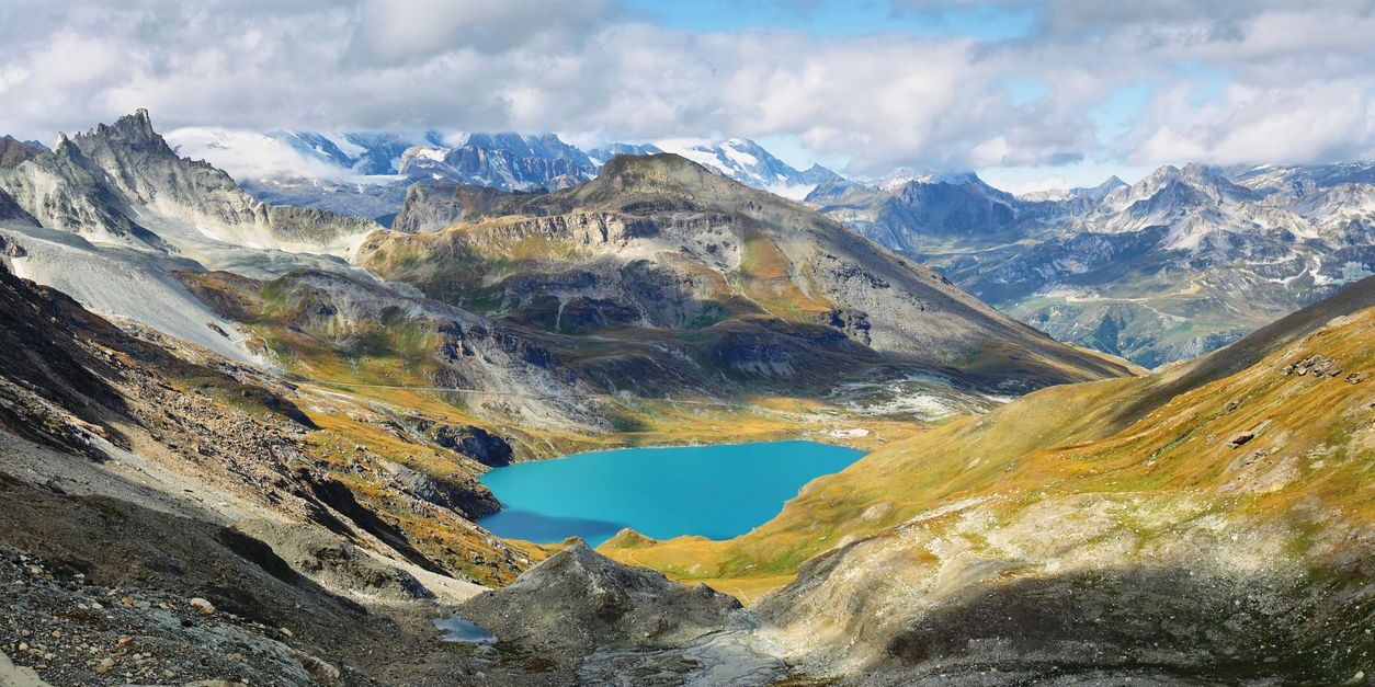
The second stage of the trail spans roughly 14 km, with a 250 m ascent and a 455 m descent. From Col de la Vanoise, you begin by descending into the Vallon de la Leisse, then continue alongside the Lac des Lozières. Eventually, you will arrive at Refuge de l’Arpont, which is found at an altitude of 2,309 m. You can rest here and even spend the night.
Stage 3: Refuge de l’Arpont → Refuge de la Dent Parrachée
Stage 3 is about 19 km, with an elevation gain of about 920 m and a descent of roughly 710 m. It takes you along an alpine balcony trail on the GR5, where you will pass by the Plan Sec and Fournache refuges. Ultimately, the route leads you to the Refuge de la Dent Parrachée at 2,511 m.
Stage 4: Refuge de la Dent Parrachée → Pralognan‑la‑Vanoise
The final stage covers roughly 19 km, with an elevation gain between 665 and 730 m. However, it has a significant descent of about 1,810 m. First, you will climb toward the Col d’Aussois at around 2,914 m, then descend along the GR55, passing through the Col de la Pêche. From there, the trail leads you toward the Repoju and Roc de la Pêche refuges before finally returning to Pralognan, completing the circuit.
Elevation & Trail Characteristics
- Total distance: Roughly 70 km
- Total elevation gain: approx. +4,000 m, day gains range 250–1,100 m
- Daily walking time: approx. 5–8 hours; hiking level: challenging (GR-rated 4/5)
- Trail marking: Mostly on GR55 and GR5. French national trail markers are red/white stripes with clear signposts
How to plan for the Tour des Glaciers de la Vanoise in 4 days?
Planning your Tour des Glaciers de la Vanoise en 4 jours might be challenging at first, but it is a practical way to prepare. You can break the circuit into four clear stages, as mentioned above, covering about 15–20 km per day with average hiking times of 5 to 8 hours.
Each night, plan to stay in mountain refuges such as Refuge de la Vanoise, Refuge de l’Arpont, and Refuge de la Dent Parrachée, which provide hikers with simple accommodation and meals.
Pro Tip: Since these huts fill up quickly, especially in the summer months, it’s best to pre-reserve your stays. You can do this at local tourism offices or on platforms like Refuges.info
What should you expect on the Tour des Glaciers de la Vanoise Trail?
When on the trail Tour des Glaciers de la Vanoise, you should expect a mix of rocky mountain passes, meadows, and breathtaking glacier viewpoints. Because the route is considered challenging, you should be well prepared physically with prior trekking experience. It’s common to see Alpine animals such as the ibex, marmots, or chamois. Please be mindful not to interact with the wildlife or feed them.
Keep in mind that the weather can change quickly at altitude, with storms hitting unexpectedly. Pack appropriate clothing and gear to aid in these weather conditions. Finally, remember that higher elevations can affect some hikers, so plan to pace yourself and stay well-hydrated.
Checklist: What gear and preparation do you need for the trail?
🥾Sturdy hiking boots
🧥Waterproof jacket
🦯 Trekking poles
🗺️ Map and GPS device
🧣Warm layers for chilly nights
🛏️Light sleeping bag liner (refuges usually provide bedding)
🥪Snacks and plenty of water (a few refill points on some stages)
🛡️Mountain trekking insurance
🏃Pre-trip training (focus on cardio and elevation gain)
Stay safe and protect the Vanoise environment
To stay safe on the trail, always check the weather forecast, keep emergency number 112 handy, and hike with a partner whenever possible.
Respect local regulations, follow Leave No Trace principles, stay on marked trails, and never feed or disturb wildlife; remember that bivouac camping is strictly regulated in the park.
Ready to experience the Tour des Glaciers de la Vanoise?
The Tour des Glaciers de la Vanoise is a challenging but amazing adventure.
If you’re ready to explore this iconic trail, make sure to reserve your accommodation with Alpvision Residences. Discover one of our many rentals as your perfect base for your Tour du Glacier de la Vanoise adventure!


